

About Alert Geomatics
Autonomous GNSS Simplified
Alert Geomatics, a division of Xeos Technologies Inc., was formed to develop new geomatics products that combine the latest in OEM GNSS receivers with advanced telemetry and embedded systems.
Focusing on precise position monitoring, these products are used for subsidence monitoring, structural monitoring as well as for science applications including polar ice and volcano monitoring. Alert Geomatics leverages Xeos’s unique experience in developing autonomous products for operation in some of the harshest environments on earth.

The Resolute-Pin RTK Base and Rover generate precision position data for subsidence and three dimensional deformation monitoring.
With a single base station, numerous Rovers can measure multiple points of interest.
Expand the capabilities of your RTK network over geographical obstructions, extending the range of the Resolute-Pin RTK Base.
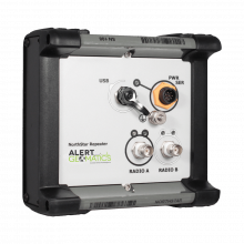
The NorthStar is a unique radio repeater designed to work an RTK corrections link for the Resolute system.
A ruggedized version of the Resolute, to extend the temperature range and conditions the Resolute can operate in.
With built in micro heaters, an IP67 rating and Iridium telemetry built in as standard, the Resolute Polar is built to withstand the harshest conditions or the Polar region.

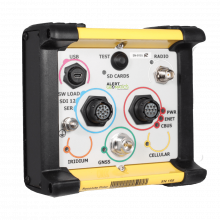
Global Access Remote Control Device
The XI-100 terminal provides you with a robust and rugged transmission platform for all your remote sensor data. Any sensor capable of transmitting data via an Ethernet connection can be connected to the XI-100, instantly providing world wide communication capabilities.
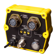
Miniature Global Remote Monitoring
The XI-202 terminal provides a robust and rugged transmission platform for all your remote sensor data. Any sensor or platform capable of transmitting data can be connected to the XI-202, instantly providing worldwide communication capabilities.